Walks starting from Trusham

Rolling hills, Devon lanes, farmland, unspoiled woods and abundant wildlife. On the doorstep.

Blackley woods walk, Trusham, Devon

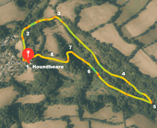
A.1. Blackley Woods
1.13 miles. Easy


1. Leave Houndbeare through the front gate. Cross Church Lane and follow the public footpath sign down a path by a closeboard fence. You pass the gate to “Trusham heights” and head down a green lane. This is also the way to the Cridford Inn.
2. As you near the bottom of the lane it forks near a field gate, take the right fork up a green lane, which is called Blackley Lane but unmarked, it is a gentle climb to the top.
3. At the top go right, through a gate into Blackley woods and follow the path around the wood, bending slightly left at an elevated level.
4. Eventually you start to descend gently and reach a path at the bottom of the wood with Bramble Brook behind it.
5. Turn sharp right and double back on the lower path below the descending one. Follow the path through the wood with Bramble Brook on your left.
6. Emerge from the wood via a gate into a field and follow the defined path through
7. It winds through a small wooded area into another field.
8. This is part of Cleave Farm, which is directly behind Houndbeare. You may be able to see the rear roof elevation of Houndbeare Barn across the field. Follow the defined path through Cleave Farm, to the North side of Houndbeare Barn and return through the front gate. 
Horses field walk, Trusham, Devon

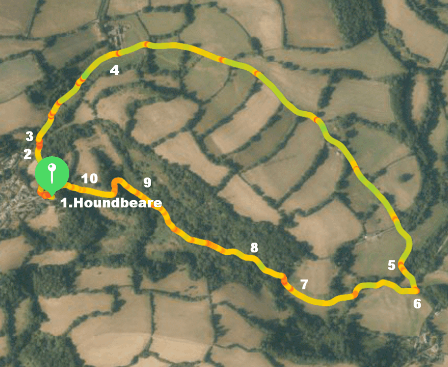
A.2. "Horses field"
2.08 miles. Easy


1. Leave Houndbeare through the front gate. Cross Church Lane and follow the public footpath sign down a path by a closeboard fence. You pass the gate to “Trusham heights” and head down a green lane. This is also the way to the Cridford Inn.
2. As you near the bottom of the lane it forks near a field gate, take the leftish fork down past the thatched “Old Rectory”.
3. Reach the metalled lane at the bottom and turn right, head out of the village.
4. You come to a fork in the road, take the right fork, signposted Chudleigh. Proceed down the hill. It is a fairly quiet lane but cars do use it so please keep dogs under control and take care.
5. At the bottom of the hill the road crosses Bramble Brook and just past it you will find a stile on the right.
6. Cross the stile and follow the path, which in a short while crosses a footbridge over the brook and into a field, which usually has horses in it.
7. Go directly across the bottom of the field and cross another stile on the far side into a wood.
8. Follow the path through the wood with Bramble Brook on your left.
9. Emerge from the wood via a gate into a field and follow the defined path, winding through a small wooded area into another field.
10. This is part of Cleave Farm, which is directly behind Houndbeare. You may be able to see the rear roof elevation of Houndbeare Barn across the field. Follow the defined path through Cleave Farm, to the North side of Houndbeare Barn and return through the front gate. 
Mobirise
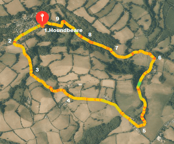
A.3. "Ruggadon"
2.88 miles. Moderate

1. Leave Houndbeare via the front gate and walk down Church Lane, past the Church on your left and into “the square” (which is more of a triangle). Go straight on past “The White House” on your right in a westerly direction out of the village.
2. You soon come to a large red brick house on the left and just past it take the public footpath on the left down a green lane and follow it to the bottom of the valley.
3. Cross Bramble Brook using the footbridge and turn right following the yellow arrow markers, then almost immediately left through a gate into Ruggadon Middle Park Nature Reserve (a Devon Wildlife Trust site). Follow the hedge on the right up to a gate, go through it and turn right over a footbridge. Follow another green lane up to join the drive to Ruggadon Farm and out onto a Devon Lane, which is usually quiet but used by cars, so take care.
4. Turn left up the lane past Twig Farm on the left and eventually Coombeshead Farm on the right. Just past it there is a junction and take the left turn, signposted Trusham. It should be signposted but wasn’t at the time of writing in February 2021.
5. Head downhill and just before Bramble Brook look for a sometimes hidden stile on the left. If you get to the brook you have gone slightly too far.
6. Cross the stile and follow the path, which in a short while crosses a footbridge over the brook and into a field, which usually has horses in it.
7. Go directly across the bottom of the field and cross another stile on the far side into a wood. Follow the path through the wood with Bramble Brook on your left.
8. Emerge from the wood via a gate into a field and follow the defined path, winding through a small wooded area into another field.
9. This is part of Cleave Farm, which is directly behind Houndbeare. You may be able to see the rear roof elevation of Houndbeare Barn across the field. Follow the defined path through Cleave Farm, to the North side of Houndbeare Barn and return through the front gate. 
Mobirise
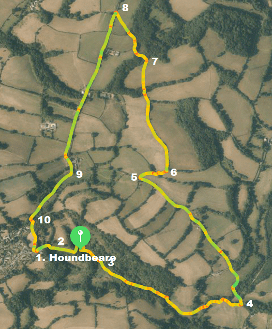
A.4. "Goat Farm"
3.25 miles. Moderate

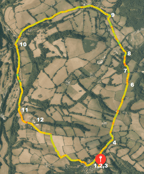
1. Leave Houndbeare through the front gate. Turn right out of the gate and sharp right down the lane past Houndbeare Barn. Go straight into the land behind the barn belonging to “Cleave Farm“ past the high fence on your right.
2. The public footpath is not currently clearly visible due to clearance works but it should pass immediately to the right of a caravan and small building and then head straight to a small copse that the path winds through into a lower field. Head slight right here diagonally to a gate in the corner which leads into Blackley Woods.
3. Follow the path straight with Bramble Brook on your right. Ignore the signed path on the left and carry straight on until you leave the woods via a stile. Now, cross straight across the field to a footbridge over Bramble Brook, then follow the fenced path with Bramble Brook now on your left to a stile into a lane.
4. Cross the stile and turn left to follow the lane uphill for about 850 meters (take care because although a quiet lane, cars do use it).
5. Turn right on a marked public footpath up a green lane. This can be muddy in wet weather. At a gate after just about 20 metres go through into a field and keep the hedge on your left.
6. You come to a gate on the left and another footpath sign, go through and follow the fenced path to a stile. Go straight and cross two electric fences.
7. Enter some woods and follow the path which goes to the left of a pond, this takes you through a field and a gate in the middle of the field up to a stile which you cross into a lane (can be cars).
8. Turn left and follow the lane down past “Martingrange Farm” on the left.
9. Shortly after, at the junction go straight on, signed Trusham.
10. Just into Trusham, take the green lane left in front of the thatched “Old Vicarage”. Climb the hill, ignoring the path left, to reach Church Lane and Houndbeare, left. 

Mobirise
A5 - Lower Ashton (The Manor Inn)
4.8 miles. Easy

1. Leave Houndbeare through the front gate. Cross Church Lane and follow the public footpath sign down a path by a closeboard fence. You pass the gate to “Trusham heights” and head down a green lane. This is also the way to the Cridford Inn.
2. As you near the bottom of the lane it forks near a field gate, take the leftish fork down past the thatched “Old Rectory”.
3. Reach the metalled lane at the bottom and turn right, head out of the village.
4. You come to a fork in the road, go straight on (leftish). Carry on slightly uphill.
5. You pass a house called Cherry Orchard on your right and about 200 yards beyond it you will see a public footpath sign in the hedge on your right.
6. Turn left here into the field and bear right, more or less parallel to the lane.
7. At the end of the field there is a stile; cross it and bear left to skirt round to the right of a copse and down a hill. At the bottom bear right to follow the line of a bank to another stile leading into a lane.
8. Go straight on down the lane passing Embercombe Cottage. Continue to Higher Ashton.
9. At the junction go straight on (leftish). You cross a stream and follow the lane for about ¾ mile to Lower Ashton. Here you find the Manor Inn and it would surely be misguided not to pop in for a rest and a drink!
10. About 150 yards past the Manor Inn as the lane turns right, turn left up a narrow track. This leads to a field which is used as a small campsite in summer. Follow the track into the field and across it. You come to a broad track which is the line of the disused Teign valley railway line. Follow it until blocked by a gate.
11. At the gate turn left off the track along a path. You will find a gate ahead of you, marked “private”. Turn right to follow a path to another gate. Cross this and a footbridge to the field beyond. Bear left up the field following the broad grassy track that goes slightly to the right of the hill (rather than the narrow path straight up). Go through a gap in the bank and follow the track with another bank on the left.
12. Go through a gate and across a yard with cottages on the left and follow the track on the other side. Go through a gap in the next hedge and continue to follow the track along the right-hand side of the next field. About 150 yards after going through the hedge you will find a stile on your right marked with a yellow arrow. Cross it and go along the right-hand side of the field. At the end of the field cross some fencing into a muddy farm lane between hedges. Turn left and when the hedge on your right ends you will find another stile marked with a yellow arrow. Cross it and follow the right-hand hedge through the field. You should now see Trusham ahead. At the end of the field follow the hedge around to your left and in the far corner you will find another stile. Beyond that the path takes you between some cottages to a small footbridge. You are now at the bottom of the village and if you go left you will come to the Cridford Inn. From here you should now be able to find your way back up to Houndeare! 

Walks on Dartmoor

Stunning moorland, woodland and villages 

Mobirise
B.1. Manaton, Kestor Inn - Houndtor
5.2 miles. Moderate
11 miles drive from Trusham

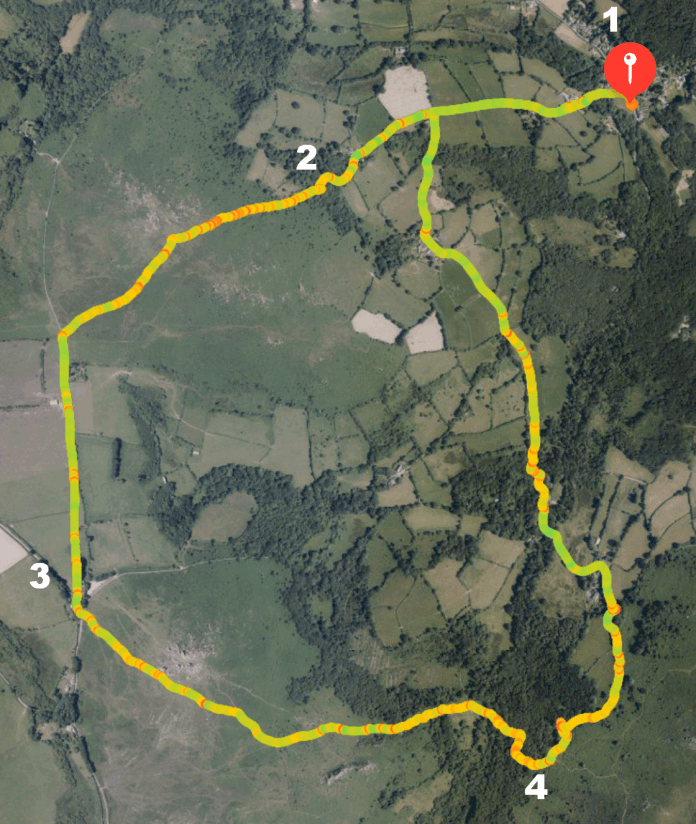
1. Start in the village of Manaton, outside the Kestor Inn. Opposite the pub there is a small lane passing some houses, all with “Deal” in their name. Follow the lane East, down to cross a stream and then climb the long hill on the other side. After about 600 yards you come to a crossroads; go straight across. When the lane ends carry on along a track, signposted to Jay’s Grave and Natsworthy. At the gate to a house, turn left along a path. It winds through a wood and climbs to Hayne Down.
2. On the down continue to climb alongside a wall on the right following the path straight ahead. Easdon Tor can be seen on the right. At the top bear left around the rocks. You can now see Houndtor and Haytor to the left. Follow a clear path down to join a road by a gate. Go through and follow the road to a T junction, where you turn left.
3. After a few yards you will see Houndtor above you on the moor. Cut across the moor towards it. When you reach the tor, go round to the right and follow a path down towards the left of the Greater Rocks lower down. You pass the ruins of a medieval farming settlement. Continue to a gate and follow the path on the other side, signposted to Leighton via Haytor Down. This takes you steeply down through a lovely wood to another gate and then down to the bottom of the valley. Go through another gate and cross the Becka Brook via a stone clapper bridge. Climb out of the valley along a rocky path and when you emerge from the wood, go left, signposted to Leighton.
4. The path runs along the edge of a field after a while, with a stone wall on the left, then goes through a gate and between two fields on the other side. You go through another gate and the path widens to a track. After a short while you will come to a junction, turn left, signposted to Leighton. The path becomes a surfaced lane and crosses the Becka Brook again. At the next junction go straight on, signposted to “road near Southcott”. Just before a gate turn left across a stile and into a wood, following the public footpath sign. Follow the path on the right, cross a stile, go left on the other side to another stile. Cross a muddy patch into a field and keep left. At the end go through a gate on the left into a road and turn right. After ½ a mile you come to a crossroads and turn right to return to the Kestor Inn. 

Mobirise
B.2. Lustleigh, The Cleave (pub) - River Bovey
4.3 miles. Moderate with some hilly climbs
10 miles drive from Trusham (6.5 across moor via Hennock, but not recommended!)

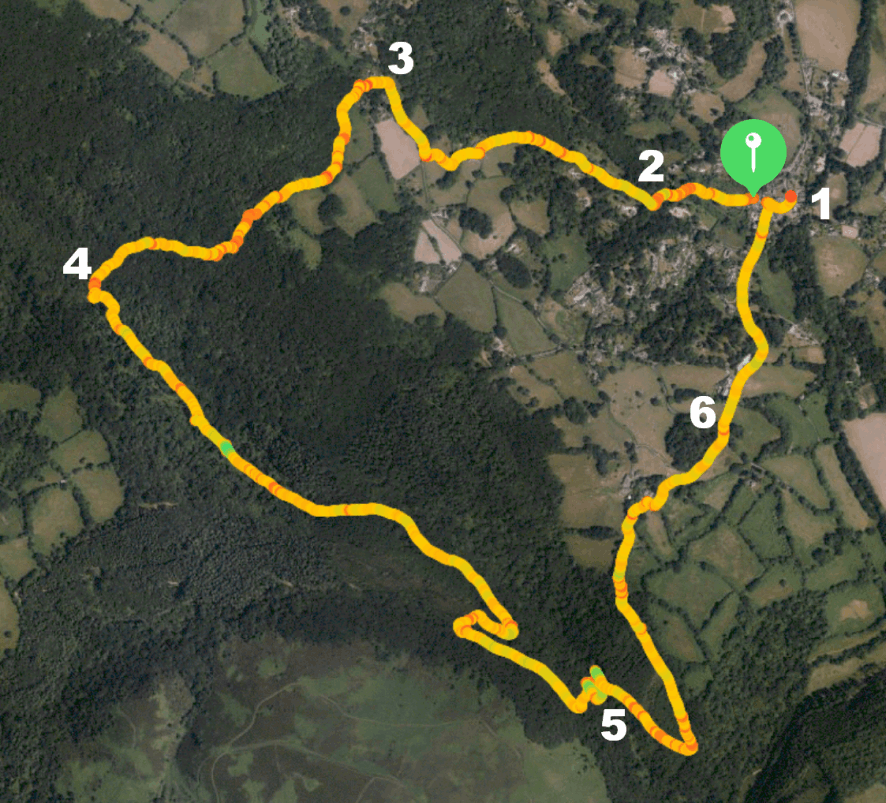
1. As if leaving “The Cleave” pub turn left in the main road. At the junction, go straight on and at the end into Town Orchard. Follow the path through the orchard and cross a stream via a footbridge, then through a gate. Follow the path on the other side through a small wood. At the path junction where it forks go left and you will come out at a lane.
2. Turn right and follow the lane as it climbs, at times quite steeply. At the T junction at the top turn right.
3. After around 200 yards, just past a house sign, Loganstones, take the footpath on the left, signposted Horsham and Hisley Bridge as well as other places. Follow the green lane through a gate then go left signposted Hisley Bridge (and others). The path climbs then descends and when you come to a junction go straight on, signposted Hisley. It goes down steeply and at the next junction go right signposted Manaton via Water then at the next junction right again, signposted the same. Follow the path down to the River Bovey where there is an old clam bridge that you can use at your own risk, or alternatively use the modern one next to it.
4. Cross the river and turn left, following the river downstream for around ¾ of a mile. It then swings right and you come to a footbridge on the left which crosses the Becka Brook. Cross the brook and turn left on the other side, signposted Trendlebere Down.
5. After around 350 yards you come to another track on the left, take it and go through a gate. Cross the old packhorse bridge, Hisley Bridge. On the other side, turn left, signposted Lustleigh Cleave and soon after sharp right on a track (off the main track) which at the time of writing (Feb 2021) was not signposted. Easy to miss but you should be going almost back on yourselves but uphill. Another climb here and you swing left with views of moorland on the left.
6. At the top the track narrows to a path between two fields. Go through a gate and continue along the path to a farm. When you come to another gate, go right and then left following the signs. Go through a gate, continue to the drive and turn right. When you come to a lane go straight across (should be signposted to Lustleigh but sign missing in Feb 2021). Descend steeply to the village, go straight on at two junctions and then at the 3rd junction turn right, back to the pub. 

Mobirise
B.3. Bridford, The Bridford Inn - Kennick Reservoir
4.7 Miles. Easy
6.8 miles from Trusham

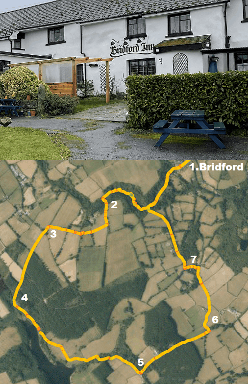
1. As if leaving The Bridford Inn turn right in the road. Follow it down and it soon becomes an unsurfaced track. It takes you to a stream, which you cross and go through a gate on the right signposted “Public footpath Laployd via Hedgemoor”. This leads you into the woods and uphill with the stream on your right. At the top you come to a locked gate and must go left up a marked footpath that ascends a little more steeply. Go through a gate and turn right.
2. Follow the clearly defined path between fences and hedges until you eventually come to a stile into a lane.
3. Turn left . After about 200 yards you will see the conifers of Laployd Plantation and the lane descends. Ignore an entrance on the left but just after there is another track on the left leading into a car park and a public bridleway. Turn in here.
4. This is the beginning of Kennick Reservoir, the first of three linked reservoirs. Follow the defined path with the conifer plantation on the left and the reservoir on the right. At a junction go straight on signposted to “Clampitt Cottage”. Keep following signs for “Clampitt Cottage” and you head away from the reservoir to a gateway and another track.
5. Turn left at this track (both directions say simply “Bridle Path”). Just beyond the farm barn on the left , there is a junction and here you go straight on, signposted “Bridlepath county road for Christow”
6. When you reach the road, turn left, signposted to Bridford. At a house on the left called “Middle Hole”, turn left through its gate and follow the drive round to a small gate to the right of the house, marked “Bridlepath”.
7. Go up the left-hand side of the field beyond to another gate. Go through and turn right, following a well-defined path and then through a small farm. Continue down towards Bridford, cross the stream and you are back to the track where you started. Turn right back to the village. 

Mobirise
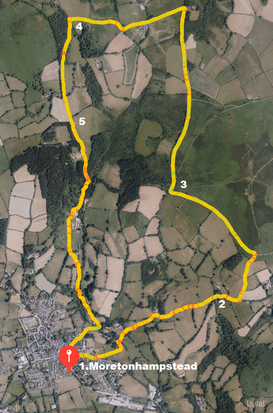
B.4. Moretonhampstead, The White Hart - Mardon Down
5.1 miles. Moderate
12 miles from Trusham

1. From the public car park near the centre on the A382 Bovey Tracey road exit and turn left walking up past the side entrance of the White Hart Hotel. Cross the A382 to Cross Street (signed to Exeter and Dunsford). Pass a row of 17th Century Almshouses on the left and go through a kissing gate left just beyond them into a park. Bear right to a gate and keep to the left of the field ahead, going down a hill to a stile. Cross it, following the sign to “Yarningdale for Mardon”, and follow the path along the left-hand edge of the field. Go through the kissing gate at the end and at the path junction after a few yards, turn right. Soon after, cross a stile into a field and keep to the right, next to a stream. Cross a stile into a small wood and then leave the wood through a gate. Do not follow the track immediately on the right but take the path just beyond it (Yarningdale for Mardon). Cross a stile into a green lane and climb between high banks. At the top go through a kissing gate onto a track, signed Mardon Down.
2. The track joins a surfaced lane and after 150 yards look for gates left. This should be signed “Bridlepath to Moor” but wasn’t in March 2021. Go through the smaller right gate and a path takes you between fence and hedge to a gate which opens on to Mardon Down. Take the path the short distance up to the road and turn left along it.
3. At the T junction in ½ mile turn right, signed Clifford Bridge. In another ½ mile you cross a cattle grid and 600 yards further on turn left at a junction, signed Chagford. After 500 yards at the next junction follow the main lane around to the right. It climbs and then descends and swings right again.
4. At a stile on the left follow the public footpath sign to Moreton, through a wood and an activity centre called “Running Deer”. Leaving the wood cross a stile into a green lane and go left. You come out at a drive, turn left and immediately right into a lane, continuing to follow the signs for Moreton.
5. After 200 yards as the lane swings right go straight down a track. When it swings right to a house go straight on a smaller track which itself bends right after a few yards, whilst you go straight on down another green lane. Descend through a wood to a gate, keeping to the bottom of the field that follows to another gate on the left. Go down some steps and then through a gate on the right. Then bear left, following the sign for Millbrook Bridge and Lime Street. Go down a field and through a gap in a bank (ignore the trodden path right at the top). Continue along the bottom of the next field and bear left through a gate alongside the stream. Cross a footbridge and a stile on the left, then turn right between fences on the right boundary. At the end go through a gate onto a lane and turn right. The lane ascends back into Moretonhampstead, the White Hart Hotel and the car park. 

Mobirise
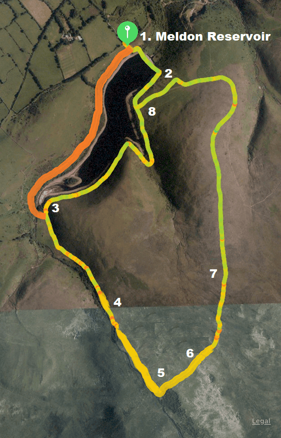
B.5. Meldon Reservoir - Blackator Copse
4.3 miles. Easy, with one climb on open moorland.
37 miles from Trusham.

1. From the car park, walk up the steps by the toilets, through the gate and go left on the tarmac road towards the dam, signed “Bridleway to Moor”. Cross over the dam.
2. Turn right along a stony track. You soon see a gate on the right leading to a waterside picnic area. Pass this and leave the track to go straight on following the edge of the reservoir through a side valley and over a small footbridge. At the end of the reservoir it descends to the broad valley of a river.
3. Pass the small footbridge taking the path on the left edge of the valley which gradually ascends with the river down to the right.
4. At the top of the slope you see Blackator Copse, a very ancient oak woodland across the open moor beside the river. With the river on your right make your way across the moorland to the copse, an enchanting place for a picnic.
5. Retrace your steps out of the copse and bear right uphill heading for the left outcrop of Black Tor on the ridge.
6. Now head slightly left from the left side of the tor, slightly downhill, crossing two or three small streams to granite blocks marking a rough but fairly distinct granite track.
7. Follow this intermittent track, eventually left around the end of the hill with views to Meldon quarry, viaduct and the reservoir. Descend to the reservoir.
8. Bear right on the track, back to the dam and cross it again back to the car park. 

Coastal Walks

Beautiful beaches, cliffs, seaside towns and villages

Mobirise
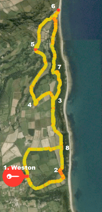
C.1. Weston (South East Devon) - Branscombe (The Fountain Inn and the Sea Shanty Cafe)
6.8 miles, moderate, with one or two steepish climbs
29 miles from Trusham

1. From the car park take the track over the stile on a footpath signposted “Weston Mouth”. As the track descends and the sea comes into view bear left on a permissive path under trees (not marked when we last did it and therefore easy to miss). It takes you on a gentle ascent to the coast path. The alternative is to go straight down and slight left in a field with a National Trust sign and join the coast path earlier. We did this and it is fine, except a bit of a climb.
2. Turn left on the coast path. Leave Weston Cliff (pass Point 8) and go through two kissing gates on Coxe’s Cliff, then the path runs inland towards a kissing gate in the top left corner of the field. Keep round the right edge of the next field and through a kissing gate on to grassland.
3. At the signpost turn half left as signed to Berry Barton. Aim for a gap in the bank on a defined track, bear left to a gate and kissing gate in the top corner of the next field, then turn left down the track to join the lane at Berry Barton.
4. Turn right to the Fountain Head Pub. Turn right again down the valley, passing groups of thatched cottages and the Church. Continue downhill through the village, which is quite spread out.
5. Turn right opposite Bucknall Close down the lane signposted “Branscombe Mouth”. After 180 metres at a path junction keep ahead through a gate and follow the path to a footbridge. Follow the path down the valley to Branscombe Beach, the Sea Shanty Café serves lovely ice creams here!
6. Turn right through a kissing gate to join coast path signs uphill beneath former coastguard cottages which are now a spectacular single private house. Go through an open gateway and left uphill to a kissing gate. Keep left up steps, then ignore paths off, pass through two kissing gates, continue for around 800 metres to where it signs left between grassy hummocks towards the cliffs. Follow this.
7. Follow the coastal path signs to re-join the cliff edge, going through three kissing gates. Retrace your steps from earlier. 
8. Turn right through a kissing gate into a wildflower meadow. Pass a cottage and outbuildings over two stiles and on to a track which comes out on a tarmac lane. Go left, back to Weston.

Mobirise
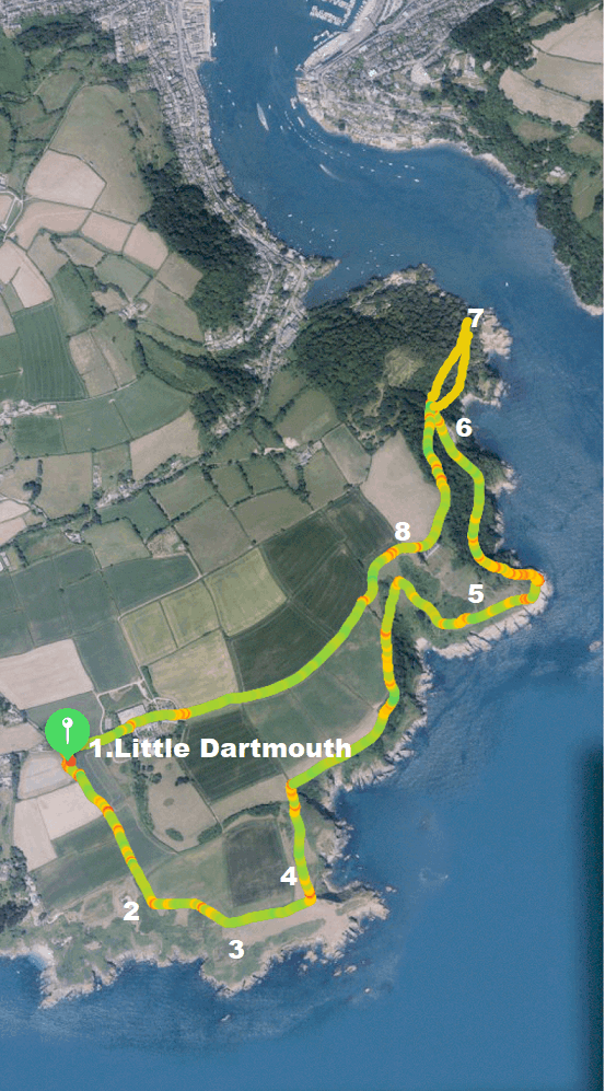
C.2. Little Dartmouth - Dartmouth Castle
3.5 miles, easy, c.5.5 miles+ if you walk in to Dartmouth
32 miles from Trusham

1. The car parks at Little Dartmouth are signposted off the B3205 (from the A379 Dartmouth-to-Stoke Fleming road). Go through the right-hand car park, following the signs “Dartmouth Coast Path”. Continue through a kissing gate, keeping the hedge right. Walk through the next field, and two gates to join the coast path.
2. Turn left. The coast path runs a little inland from the cliff edge, but you can always walk out on to Warren Point (a plaque reveals that the Devon Federation of Women's Institutes gave this land to the National Trust in 1970).
3. From Warren Point follow the coast to pass above Western Combe Cove (with steps down to the sea) and then Combe Point (take care, it’s a long drop to the sea from here).
4. Re-join the coast path through a gateway and follow it above Shinglehill Cove. The path turns inland, passes a pond and follows a track, then bears right along the back of Willow Cove. It passes above woods (with a field left), then climbs to pass through a gate. Follow the yellow arrow ahead to a footpath post, then turn sharp right down the valley, bearing right at the bottom to a stile as signed. Follow the path on, and through a gate near Compass Cove.
5. Follow the coast path left over a footbridge, and continue towards Blackstone Point. The path now turns inland to run along the side of the estuary through deciduous woodland.
6. The path meets a surfaced lane opposite Compass Cottage; keep ahead on to the lane and immediately right again steeply downhill. Follow coast path signs right to zig-zag steeply down then up steps to reach a turning space, then go right down steps to reach the castle.
7. Retrace your route up the steps, then turn left to Point 6, then left to pass Compass Cottage, and continue up the steep lane (signposted 'Little Dartmouth') and through a kissing gate on to National Trust land.
8. The path runs along the top of a field and through a five-bar gate on to a green lane. Go through a gate and the farmyard at Little Dartmouth and ahead on a tarmac lane to the car park. 

Mobirise
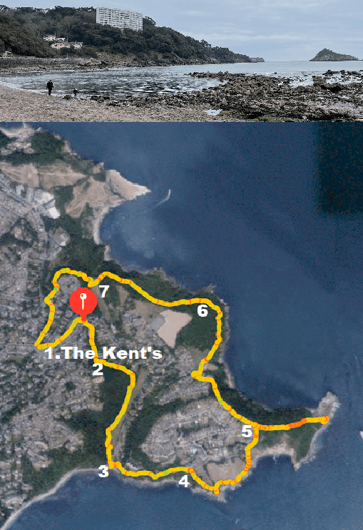
C.3. Torquay, The Kent's - Thatcher Rock and Hope's Nose
4.6 miles, easy.
16 miles from Trusham

1. As if leaving the Kent’s pub, turn right, down Ilsham Road, as signposted for Kent’s Cavern. Fork right as signed for the Kent’s Cavern Caves and take the public footpath past their entrance. Continue along a narrow path, through a wooded slope, with houses and gardens on your left.
2. Bear left, downhill, at the lane junction. Now with woodland on your right and a park on your left. At the bottom go through a gap by a gate into the bottom of the park and right down a path that crosses the road to the car park for Meadfoot Beach.
3. From the left of the car park take the coast path to Anstey’s Cove, up some steps with the sea on your right to a top road, turn right.
4. Bear right down the signposted Coast Path which leads you out to Thatcher Point, overlooking Thatcher Rock and “The Ore Stone”. There is a bench here, which is a good spot for a break. Come back slightly and continue along the Coast Path which leads back to the road further up. Follow the road to the right again and further up you can cross a stile right signed for Hope’s nose. Walk down as far as you want and then back.
5. When you return to the road, go up steps beside it and follow the path above the road , descending to carefully cross the road and follow the path again, signed for Anstey’s Cove, “Bishop’s Walk”. Turn left after 50 yards at the first signposted junction.
6. Fork left on the higher path, later ignoring a steep track on the left and continuing straight. You come out opposite the car park for Anstey’s Cove. You can go right down to Anstey’s Cove and come back the same way if you wish.
7. Cross to the car park and take some steps from the front right hand side up through woodland. Emerge on the Babbacome Road near a bus stop and go left, back to the Kent’s pub. 

Wild Water Swimming

Fabulous walks that give you the opportuunity to take a dip!

Mobirise
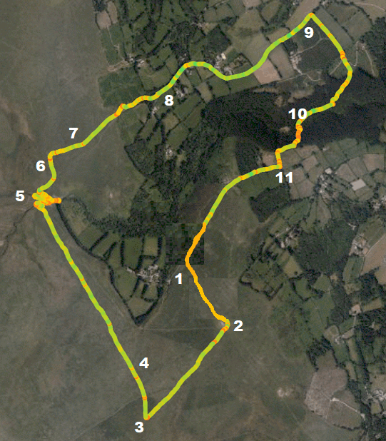
D.1. Kestor Rock - Scorhill Stone Circle
5 miles. Easy.
19 miles from Trusham

1. Park in one of the small parking areas in TQ13 8EU with a view up to Kestor Rock on the hill. Take a path directly to it.
2. From Kestor you can see the Long Stone (a smallish “spike” of rock) to the South West. Take the path to it.
3. At the Long Stone take the path to the right, to the north, you feel like you are heading back to where you started.
4. You reach two double stone rows – follow the path by the left hand stone row. Walk along the path with the wood and stone wall some distance to your right.
5. You reach the Teign-e-ver clapper bridge. Turn right and walk along with the river on your right. After a few minutes you reach the first swim spot, by a second very crude clapper bridge. You are on a small peninsula. To reach the Tolmen Stone and second swim spot walk to the end of the peninsula and cross a small stream on your left then go a little further downstream. It can be a bit confusing but persevere and you will find it.
6. Retrace your steps and cross another clapper bridge over the Wallabrook and follow the path north east to Scorhill Circle.
7. After looking at the circle take the track North East which takes you off the moor via a wooden gate.
8. Walk down the lane and turn right at the T junction following the sign for Berrydown and Gidleigh. There is a wooden fingerpost saying Mariners Way and Road to Kestor Rock.
9. You reach a gate on the right which says Gideigh Wood (not the first private one, the second). Take the track through the gate and into the woods. The path splits, take the right hand path into some trees (not the very broad track sharp right).
10. You will start to hear the river to your left. Ignore the sign right and walk along with the river on your left. Follow the path to the left , cross the Clam bridge and follow the path uphill to the right. Keep going uphill, cross a track, and at the top turn right following the public footpath sign. Then turn left following the Path sign.
11. Go through a gate/stile then turn right in the lane and follow it back to where you parked. 

© Copyright 2021 sarah.bond@houndbeare.com. All Rights Reserved.

Page was created with Mobirise